Travel in South America
2001 is proving to be a busy year for traveling. Earlier this year I took a short trip around Lake Superior. November saw me leaving for a much longer trip to the "End of the World", as it is referred to in Chile, and parts north. A total of three weeks were spent mostly in Chile, but with a few days in Argentina as well. This trip has proven to be one of the most diverse trips I've taken in terms of landscapes and geology. The trip was a group excursion organized by the Smithsonian Institution. Travel began on November 11, with the entire group gathering in Buenos Aires, Argentina on the 12th of November. A couple of days were spent in Buenos Aires, before flying off to Ushuaia. There we boarded the Terra Australis for a 3 day cruise through the Beagle Channel and Straits of Magellan to view the glaciers and fjords of Tierra del Fuego and the southern most part of the Andes Mountains. The group then disembarked at Punta Arenas, Chile and drove north to Torres del Paine National Park for three days of hiking and exploring. Igneous intrusions, tectonic deformation, and glacial erosion dominate the dramatic landscapes of the park. From the far south, seven of the group members, including myself, flew to the far north to the desert landscapes of the Atacama desert. Here desert, dunes, salt deposits, dormant and active volcanoes of the Andes, lava flows, ash deposits, hot springs, geysers, deformed sediments, and erosion all competed for our attention. Officially the Smithsonian excursion ended on November 26th. However, that wasn't the end for me. I stayed on in Santiago for four additional days to spend some time in the capital of Chile, Santiago, and to visit the central Andes and coastal areas near Valparaiso.
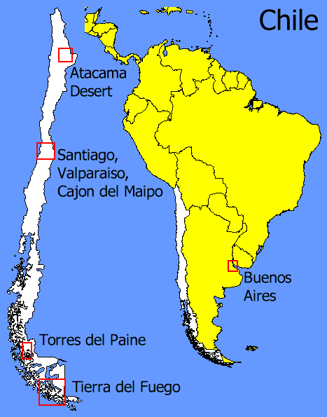
Below you will find a map outlining the major areas that were visited during the trip. These, in addition to the links on the left side of the screen, will link you to additional pages with more detailed information on the excursion schedule and activities, as well as summaries of the geology of some of the more interesting features. Throughout these pages you will also find links to numerous pictures of the sights and geology of the areas visited.
The map of Chile and South America shows the areas that were visited.
Click on the outlined area to view information, maps and pictures from that area.